The U.S. Army Corps of Engineers, the lead federal agency for permit decisions on the Pebble project, has finalized an Environmental Impact Statement (EIS) disclosing impacts of a 20-year mine plan proposed by the Pebble Limited Partnership (PLP) and parent company Northern Dynasty Minerals (NDM).
Although it is a significant milestone, the publication of the EIS is not the conclusion of the federal permitting process. The Corps will continue to work on a Joint Record of Decision (JROD) that will indicate its decision on whether to grant or deny a Clean Water Act 404 permit that PLP needs to develop the mine site in Bristol Bay.
There is no maximum timeframe stipulated for completing the JROD, but it must be at least 30 days after publication of the final EIS. In a media call earlier this week, David Hobbie, Chief of the Regulatory Division for the Corps’ Alaska District, said they hope to complete it quickly, anticipating it “sometime later this year.”
What’s in the EIS?
The EIS covers the purpose and need of the project, alternatives considered, a description of the affected environment, environmental consequences, and mitigation. The full version, including appendices, is 5,412 pages and includes a listing of the concerns the Corps addressed in its analysis. Read the Executive Summary.
Permanent, temporary and indirect environmental impacts from the project are listed, and would include:
“In summary, development of the mine site would permanently remove approximately 99 miles of streambed habitat in the NFK and SFK drainages. Direct effects on fish, including displacement, injury, and mortality, would occur with the permanent removal of stream habitat in the NFK and SFK drainages due to mine site construction. Stream productivity in the NFK and SFK drainages would be reduced to some degree with the loss of physical and biological inputs. These impacts would be permanent, and certain to occur.” – Pebble EIS Executive Summary, page 81 (p. 87 in PDF).
Note: NFK= North Fork Koktuli, SFK = South Fork Koktuli
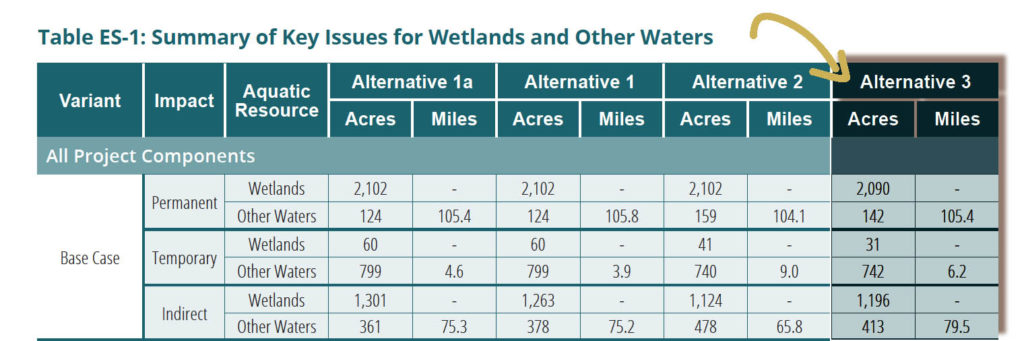
“The total direct impact to wetlands and other waters under Alternative 3 is the discharge of dredged or fill material to 3,005 acres of wetlands and other waters, including 111.6 miles of streams. Of this area of direct impact area, 2,231 acres of wetlands and other waters and 105.4 miles of streams would be permanently impacted; 773 acres of wetlands and other waters, including 6.2 miles of streams, would be temporarily impacted. Indirect impacts under Alternative 3 related to the fragmentation, deposition of dust, and dewatering of aquatic resources collectively have the potential to impact a total of 1,609 acres of wetlands and other waters, including 79.5 miles of streams.”
– Pebble EIS Executive Summary, page 98 (p. 104 in PDF).
Evolution of the EIS
- The Corps published a draft EIS in February 2019. Comments from the public and state and federal agencies highlighted serious concerns with the document.
- Out of 8,427 unique comments received during the public input period, the Corps determined that there were 748 “Statements of Concern” to address. (More than 311,000 comments were received, but many of them were duplicate form letters.)
- The Corps revised the EIS and made a preliminary final version available to cooperating agencies in early 2020. Bristol Bay Native Corporation (which also sponsors the Pebble Watch program), documented a list of concerns agencies had with the preliminary final.
- Since March 2020, the Corps has been working with cooperating agencies to address their outstanding concerns. As the lead agency for this process, the Corps has the final say when there are disagreements.
LEDPA, Public Input, and Land Issues
A major part of the National Environmental Policy Act (NEPA) process is to determine how a project can be done in the least-environmentally damaging way. It also has to be “practicable.” Those two requirements together are called the LEDPA, or Least Environmentally Damaging Practicable Alternative.
During the permitting process, the Corps considered Pebble’s “preferred alternative,” which included a ferry transport system across Iliamna Lake. It also considered alternatives to Pebble’s preferred plan.
In April 2020 the Corps designated Alternative 3 as the LEDPA. This alternative is commonly known as the Northern Route, as it goes along the northern shore of Iliamna Lake, not across it. Alternative 3 has a larger overall footprint, but the Corps says it has fewer impacts.
PUBLIC INPUT
In 2017, when Pebble developers announced their plan to build a port at Amakdedori and run a ferry across Iliamna Lake, it was a surprise, partially since that route had already been considered and rejected during transportation corridor studies in both 1991 and 2004.
As the “applicant’s preferred alternative,” the Iliamna Lake crossing, Amakdedori port and road butting up to the McNeil River State Game Refuge was the main focus of Pebble’s materials and on the Corps’ Pebble permitting website describing the project. (It’s now called “Alternative 1a.”)
Scientists, agencies and the public sounded the alarm on the preferred route, citing many issues, including potential effects to brown bears and Iliamna Lake freshwater seals. These concerns were highlighted during public hearings and in comments on the draft Environmental Impact Statement.
After the Corps informed Pebble of its LEDPA determination in April 2020, the company changed its preferred alternative and updated its permit application. Critics say that should initiate another public input period. Read the updated application, made available to the public July 23. (Download all related files – 78 MB)
That’s not how the process works, according to Hobbie. The public had the opportunity to submit comments on Alternative 3, even if all the attention was focused on the Iliamna Lake option. In fact, Hobbie explained that all the public concern drove the Corps to Alternative 3 as the least environmentally damaging option.
All of the alternatives will damage the environment, he acknowledged. By regulation, the Corps must determine the option that will have the least damage.
LAND OWNERSHIP
There’s a reason people may have dismissed Alternative 3 as a practicable one. That’s because developers don’t have land access they’ll need in the area of the port and along part of the road corridor. Pedro Bay Corporation, Igiugig Village Council and Bristol Bay Native Corporation all say they will not give Pebble access to their lands.
The Corps has been asked about this issue on multiple occasions. If developers don’t have access, doesn’t that mean that Alternative 3 is not practicable? Not so, said Hobbie. He explained that since Pebble says the route is still practicable, the Corps must assume that it is.
A public affairs spokesperson for the Corps said that the northern access route and port would fall under consideration for alternatives due to Regulation 33 CFR 320.4(g)(6):
DA permit does not convey any property rights, either in real estate or material, or any exclusive privileges. Furthermore, a DA permit does not authorize any injury to property or invasion of rights or any infringement of Federal, state or local laws or regulations. The applicant’s signature on an application is an affirmation that the applicant possesses or will possess the requisite property interest to undertake the activity proposed in the application. The district engineer will not enter into disputes but will remind the applicant of the above. The dispute over property ownership will not be a factor in the Corps public interest decision.
What’s left in permitting?
Pebble must acquire three federal authorizations for its plan, including the Corps of Engineers 404 permit, permission from the Coast Guard to build a bridge over the Newhalen River, and a pipeline right-of-way from the Bureau of Safety and Environmental Enforcement (BSEE).
The Coast Guard and the Army Corps will release their permit decisions at the same time, in the Joint Record of Decision.
BSEE is considering the Pebble project’s application for a Pipeline Right-Of-Way (ROW) in the Cook Inlet Outer Continental Self (OCS). BSEE pulled out of the Joint Record of Decision process earlier this spring, when it was determined that its own timeline for decision making was not synching with that of the Army Corps. BSEE has not indicated an expected date for a decision on Pebble’s application for the Pipeline ROW authorization.
The Pebble project also needs authorizations from the State of Alaska. That process has not begun, but is anticipated to take approximately three years.
Read More
Anticipating the Record of Decision
Partnering on Pebble Still Up in the Air
What You Won’t See in the Next EIS